DOT Unveils I-440 Widening Plans
Today the NC Department of Transportation held an information session regarding the I-440 widening plan. Construction on this final piece of “The Beltline” to offer only four lanes, is slated to break ground in 2018, and will likely take two years to complete.
The scope of the project involves Interstate 440 from the I-40 interchange at Crossroads (The Belt Buckle) to the Wade Avenue interchange. It is a stretch that is only 3.75 miles long, but has a significant number of difficult challenges from replacement of all bridges to dealing with terrain problems to overcoming constrictions set by limited right-of-ways.
Let’s look at the key elements, moving from North to South:
I-440/Wade Avenue Interchange
project pdf
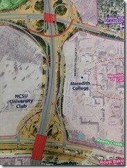
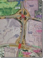
The existing problems with this area lie with a heavy traffic load in the afternoon on the ramp from inbound Wade to 440 Eastbound (440E), a short weave under the bridge on Inbound Wade, a short weave on 440E between Hillsborough and Wade, and a short weave on 440W’s bridge over Wade. Planners intend to solve the first two problems by replacing the Wade/440E loop with a flyover bridge. Dealing with the other problems gets extremely tricky, but each plan has one other common feature: the elimination of the Outbound Wade/440W loop. ITB drivers wanting to go to Cary will have to make a left turn after the 440 overpass at a traffic signal. The other options mainly deal with getting traffic on/off of 440E to/from Hillsborough and Wade; the segment bordering Meredith College.
One Flyover
 This option puts all traffic coming from Cary onto a 2-lane resurrected loop on the NE corner of the cloverleaf. Traffic headed inbound on Wade waits at a left turn signal while traffic headed outbound continues from the loop into Wade. Hillsborough Street traffic headed out Wade blends with offcoming 440E traffic while cars getting on 440E dives under a new offramp bridge.
This option is the least expensive and offers Hillsborough Street drivers an unimpeded path to Wade Outbound and puts traffic directly onto Wade Avenue (see Two Flyovers). The main problem is that it keeps an unnecessary traffic signal stymying both directions of Wade. Why not keep the off-ramp for Inbound Wade traffic, give outbound their loop, and eliminate the current traffic light?
Two Flyovers
 The Two Flyovers option takes traffic on 440E headed to Wade Outbound on a flyover that would merge with offcoming 440 West’s heavy traffic, before merging onto Wade. Traffic headed inbound on Wade uses the current offramp and right turn.
The option makes all traffic coming from Hillsborough have an easy route and removes the existing traffic signal at Wade Avenue. The option keeps speeds higher, reducing bottlenecks, supposedly.
Actually this option would be an expensive nightmare, as then all 440 traffic headed to Wade Avenue west would have to merge with each other as well as short-weave with Wade Avenue traffic before the Blue Ridge Road offramp. Because the Blue Ridge Road offramp is not a part of this project, it cannot be changed and introduces a severe problem with the Two Flyover plan.
Slight Detour
 The Slight Detour plan takes 440E traffic headed out Wade through a resurrected 1-lane loop on the NE corner of the intersection. 440E’s Inbound Wade traffic and all of Hillsborough Street’s traffic would proceed to the current Wade Avenue signalized intersection, where Wade Inbound, Wade Outbound, and 440E can be accessed.
This plan handles the 440E to Wade Outbound traffic beautifully, as the traffic merges onto Wade before 440W’s offramp merges. The plan puts a weird burden on the Hillsborough-borne traffic however.
The strongest option of the three, as drawn, is the One Flyover because it keeps traffic from Hillsborough Street flowing best, however an Inbound off-ramp would be the best option as it removes an unnecessary traffic light from Wade Avenue’s flow.
I-440/Western Blvd
project pdf
 Raleigh is about to get its first Diverging Diamond Intersection (DDI)! The DDI takes the Western Blvd traffic and swaps sides of the road near the 440 overpass. Each swap is managed by a 2-stage traffic signal, making the intersection easily traversed by pedestrians while keeping Western Boulevard’s traffic flowing well.
DDI intersections are strongest because the swap allows extremely safe, easy left turns onto and off of the highway’s ramps. Initially some are terrified at the thought of swapping the sides of the road, however these intersections are well marked and really feel like a one-way street. They are no scarier than a SPUI interchange, like the one at Southpoint Mall on I-40.
I-440/Jones Franklin
project pdf
 The current problems with this intersection are a double traffic light on Jones Franklin (because in the 70s a new apartment complex was allowed to access the road 50 feet from an off-ramp intersection), an extremely dangerous pedestrian situation on the overpass, a short weave on 440E between I-40 and Jones Franklin, and 440’s shortest onramp (Jones Franklin onto 400E).
Where do we start? To begin with, the 440W offramp will be realigned with the apartment complex’s street, creating a single signal intersection. Engineers intend to use a weave (bridged swap) to avoid the current short weave between I-40 and Jones Franklin on 440E.
The realignment will improve dramatically the intersection on the north side of the interchange. The weave? I don’t see much of a problem with the current short weave, and don’t think it needs to be addressed.
One problem, however, with the plan is that it shows Jones Franklin with four northbound lanes between the traffic light and Waters Edge. There is currently a northbound TTA bus stop in that segment (green dot). As designed the TTA bus would have to accelerate across two lanes of traffic through a T intersection after loading passengers.
When I proposed moving the stop to the south corner of the ramp/Sumter intersection (blue dot), the DOT engineer laughed in my face. No way is NCDOT going to allow a bus stop in their intersection, apparently. I was stunned, and appalled, in fact. The proposed intersection could easily be marked with crosswalks and signalized to handle a bus stop before the intersection. It is a far more safe manner than the engineer’s proposal of keeping the stop where it is.
I-440/I-40
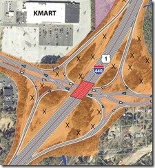
The “Belt Buckle” is an intersection needing much improvement. Traffic merging from Crossroads Plaza has to traverse 2 lanes of traffic still hot from a 65mph speed zone. There is a short merge under the 40 bridges, and it creates backups on the US1 North segment of road.
DOT proposes a flyover for 40E traffic headed onto 440E. The plan removes the current loop for this move and solves the short weave problem under the bridge. Seriously, though, who does this move? Of the cloverleaf’s options, that’s probably the least utilized option. If all other things are equal, the flyover should be for traffic moving from US1N onto I-40W. Environmental and legal constraints apparently prohibit DOT from obtaining this land. (I haven’t written about this yet, but David Martin has wanted, for years, to put “Crossroads Towers”, 4 office towers and a hotel ranging from 10-62 stories each, on that land. Stay tuned).
Even more interesting about this intersection, however, is that there is a feasibility study going on right now to examine redoing the entire 440/40 intersection. In other words, a comprehensive overhaul may be coming anyway for this intersection, which means that DOT will likely take the options to just widen 440 to 40 and not touch the intersection for this project.
There are other aspects about this project that don’t require much discussion. The Melbourne Road bridge will be replaced, and the intersection will not close, for instance. DOT also plans to keep Method connected to a cemetery in the shadows of Westgrove Tower, as well.
* * *
However the four big interchanges are the story here. Interim routing will be fascinating, as major changes such as those proposed will require an exquisite amount of detouring during the project.
No Comments
Make A CommentNo comments yet.
Comments RSS Feed TrackBack URL
Leave a comment
Recent Stories
- 2015: A Year of Openings and Closings December 31, 2015
- Raleigh’s Top 30 Stories for 2015 December 31, 2015
- 16 Podcasts To Save You from Sports Radio October 23, 2015
- Public Meeting on Fairview Fire Station Coming Monday October 5, 2015
- Parade of Homes Begins Tomorrow October 2, 2015
- Oktoberfest Coming to Booth Amphitheatre This Weekend October 1, 2015
- Traffic Circles Removed from Currituck Design April 28, 2015
- 125 Concerts to Rock Your Summer April 3, 2015
- Cameron Village Planning Parking Decks April 1, 2015
- Let The Madness Begin! March 17, 2015
- Fury 325 Test Run POV Hits Internet March 6, 2015
- North Carolina Loses The Great Teacher February 9, 2015
- City Lays Markings for Currituck Obstacle Course February 4, 2015
- History Making Heels and Wolfpack Prepare for Battle January 14, 2015
- 25 Predictions for 2015 January 5, 2015


