
Smart Communte Challenge Begins Wednesday
On April 15 sponsoring groups GoTriangle, SmartCommute@rtp, and Triangle Air Awareness will kick off the 2009 SmartCommute Challenge. The Challenge is an annual non-profit public service campaign aimed at reducing traffic congestion and improving air quality in the Triangle. The SmartCommute Challenge encourages commuters and college students who work or attend classes in Durham, Wake, or Orange Counties to try a different commute. Commuters can take the Challenge to try the bus, carpooling, vanpooling, teleworking, biking, or walking at least once.
The six-week challenge runs through May 30. The officially kicks-off celebration will be at The Research Triangle Park Headquarters (12 Davis Drive) on April 15 at 9 a.m. This year’s festivities will feature the kick off of the Triangle Air Quality Forecast Season, alternative fuel vehicles, and testimonials from Triangle commuters who use various forms of commuting alternatives.
Faulty Transit Poll Fails To Direct Region
Last week “Raleigh-Cary” was ranked as the fastest growing area of the country. Great! Now what? As a region we have to decide where these people are going to live. Do we want to be a gridlocked region where it is difficult to move about? Do we want to spend our transportation dollars wisely? Is there a new growth model that should be used? Many, many questions need to be answered.
The answers to some questions were released this week by the Regional Transportation Alliance (Warning: autostart Video). The group is a collection of business leaders and chambers of commerce that has a stated goal of improving transit in the region, however their behaviors in the past demonstrate a distinct bias toward high-capacity train transit.
While this poll (.pdf) isn’t as blatantly biased as previous polls centered on the transit subject in the area, the poll clearly has massive flaws. The Alliance’s press release (.pdf), which pushes only the data that conforms to the agenda, doesn’t help in building the trust of the general public.
The survey was conducted in early March and contains 20 questions. I’ll dissect each one:
WRAL Now Twittering Traffic Info
You can now get local traffic updates via Twitter. Simply follow Brian Shrader’s handle, wraltraffic, and you’ll get text data (that is infinitely more accessible than the iPhone’s worthless Google Maps GPS functionality)
License Plates Returning to Blue
WRAL has a story about the NCDOT’s Tuesday announcement that the state will return to using blue letters on its license plates. The state dropped the original blue-letter design in favor of red lettering two years ago to assist in identifying older plates. However, the red-letter tags were not nearly as legible as their blue predecessors. In February the state announced that it will discontinue its production of flat tags as well, returning to the embossed plates. Legibility problems and their close resemblance to unofficial novelty plates plagued the flat plates.
It is great that the state claims that they are making legibility a priority. It is important, especially in the case of a hit-and-run, to quickly identify a car’s license tag. However if this is truly a priority, shouldn’t they also ban license plate frames that obscure the state name, too?
R-Line Offers Easy, Cheap Downtown Movement
 Last week the city unveiled a free downtown circulating bus line. The “R-Line” includes 20 stops in the the Glenwood South, Convention Center, City Market, and state government areas on a frequent rotation with comfortable, clean buses.
The buses purchased for the route are BRT hybrid powered and large. There are about 35 seats with plenty of standing room, space for the handicapped, and a bicycle rack on the front. If anything, the buses are too long, struggling to negotiate some of downtown’s tighter curves. The paint job is tactfully eye-catching, and includes the service’s characteristic “R” logo. There is no display ad space at this point inside the buses, but there are two mounted video screens which will certainly run advertising loops in the future.
 The twenty stops are well-placed; within 3 blocks of just about every downtown location. The buses run heads-up announcements of upcoming stops, much like those heard on rail transit lines. The announcements are prompted by a GPS system, however when I rode the line, only about half of the stops were announced. One important stop, “State Capitol”, was not announced.
Hours
- Mon-Wed (7 am-11 pm)
- Thurs-Sat (7 am-2:15 am)
- Sun (1 pm-8 pm)
Quirks
- The 40’ buses cannot pass under the railroad overpass on Peace Street, so the buses to not service the Mellow Mushroom corner. Rather, walk a couple of blocks down the hill to the stop across from the Red Room.
- The route only runs counter-clockwise, and takes 20-30 minutes to complete the one-way loop. If your destination is a 10-minutes bus ride away, allow 10-20 minutes for your return trip.
- The route only serves City Market and the Humble Pie areas after 6:30. During the day the route proceeds straight up Wilmington and straight down Dawson. Compare the routes before 6:30 pm to after 6:30.
- NCSU Students can now enjoy the Wolfprowl Service, which connects the northern campus to western downtown. Wolfprowl riders can transfer to the R-Line at two places: Flying Saucer, and The Dawson. Wolfprowl also has a stop at Snoopy’s, but it is not a transfer point to the R-Line. Wolfprowl map (.pdf)
Maps
Auto Show Underway
The 2009 Auto Show began yesterday at the Raleigh Convention Center. Absent from the show are GM and Ford products, according to WRAL. Hwoever Mercedes-Benz, BMW, Jaguar, Audi, Porsche, Acura, Maserati and more are on the floor.
Tickets are $5 (12 and under free) and the show runs from 10am to 9pm today and Saturday. It will run from 10am to 6pm Sunday.
Cameras are welcome.
I-40 Intersection Continues To Vex
Tonight a fiery five-vehicle accident on Interstate 40 has had traffic at a crawl for over 3 hours now. According to reports, an eastbound car swerved after missing the Wade Avenue Exit on Interstate 40. After cutting across multiple lanes, the car collided with an 18-wheeler, two other cars, and a garbage truck. The garbage truck overturned (spilling garbage all over the road) and burst into flames.
 It’s a wonder that this kind of accident doesn’t happen more frequently. It seems that at least once every three times I approach the intersection I see a vehicle swerve at the last moment possible. I was so curious about the frequency of this move that I sat on the right shoulder of the road and observed several dangerous swerving instances.
 I sat for 6:00 minutes and counted 12 vehicles swerving at the last moment. Think about that: once every thirty seconds, someone is performing an incredibly dangerous maneuver at 70-80mph. Many were cars, but even more disturbing was the number of trucks swerving.
The question is why: why is this intersection so vexing to people? NCDOT has re-signed the intersection a few times since widening was completed nearly 20 years ago. Still, though, there is something horribly wrong with the design and or signage that is causing some extremely risky behavior.
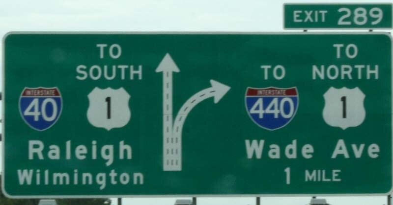 Sign 1: Moving eastbound, we pass the crest of Harrison Avenue hill, and proceed downhill, seeing well in advance that an intersection is ahead. The first sign shows a four-laned road splitting to two-and-two. The pair to the left is labeled “40, Raleigh, Wilmington” while the right pair is labeled “440, Wade Ave”.
While the sign is accurate, and stays true to the signage rules of labeling routes to downtowns, the sign is confusing. Wade Avenue is part of “Raleigh”. Additionally, to a motorist moving 70-80mph, “40” and “440” are extremely similar. Let’s do a simple exercise. Tell a friend that you are going to say five numbers to them. Say this tongue-twister out loud to them:”40-440-440-40-440″. Then ask which one was in the middle. Ask them which was said more times. Now say this “40-840-840-40-840”. Ask the same questions and see how much more accurate the response is.
 Sign 2: This sign was placed after years of confusion. It tells motorists that “Downtown Raleigh” is straight, and North Raleigh is to the right. Well, that’s not that accurate, either. What about West and East Raleigh? How do we get there? Wade Avenue one of West Raleigh’s signature roadways, not one of North Raleigh’s.
 Sign 3: This is the original signage. It states the information from Sign 1. Raleigh, Wilmington, and “40” are in the left two lanes. The right two lanes are “Wade Ave” and “440”. An additional clue is given with this sign, though. It informs that the right lanes are exiting the highway.
 Sign 4: This little bitty sign tells sports fans and concert-goers that they need to take Exit 289. I like this one, though it should be a brown sign, like those for Walnut Creek Amphitheatre.
 Sign 5: A repeat of sign 3. At this point some driver around you is in a sheer state of panic. 40-440-440-40-440…Which one!??
To me the main problem lies in calling Raleigh’s beltline “440”. Once again it stays true to the Federal Highway Administration’s rules for naming interstates. However it begs the question: Why do we have these rules? Isn’t it for clarity? Why do we need clarity? ahhh yes, to prevent accidents, of course.
There are a few inexpensive signage improvements that should be tried. The bracket for Sign 4 should also have a large yellow “RIGHT LANES EXIT” sign, with two arrows pointing to the lanes.
Also, Sign 2 should not show a simple “Y”. Rather, it show the true shape of the intersection. The sign should let people know that the left two lanes actually turn to the south while the right two lanes bypass the intersection and ultimately end up straight ahead. Anyone with a decent inner compass is going to assume that the right two lanes veer off and head south, while the left two continue east. This sign should also carry the “40” badge next to “Downtown Raleigh”, but should not carry a “440” badge. Interstate 40 is the dominant highway, and some distinction needs to be drawn between the two roads to passing motorists. Finally, the right half of the sign should read “West and North Raleigh”.
 Perhaps those two improvements would help. However the best solution is to rename 440 to something else. 240, 640, 840 are all taken, supposedly. What do they do in states with more than 4 loop highways? Duplicates should be allowed. I prefer duplicates within a state to…say…flaming garbage.
Let’s also get away from calling it “The Beltline”, which incorrectly implies a closed loop. (A more correct name would be the Midtown Arc, but nobody is going to seriously accept that!)
The high level of danger and confusion in such an intense situation is going to lead to far more accidents. The DOT and the FHA need to spend more time fixing this problem and less time trying to explain how wonderful their pointless nomenclature is.
New Lighting for Pedestrian Bridge
Last week public and private sector leaders toasted the new lighting for the beltline’s pedestrian bridge (next to the Wade Ave. intersection). The bridge is now adorned with 120 LED light fixtures in addition to additional LEDs installed within the columns of the bridge. The project was made possible by Cree, ETG, Lumux, the N.C. Museum of Art, Raleigh Parks and Recreation, Colorume’s Colorlume’s Jeff Brown, and the NCDOT. Check it out the next time you pass by at night.
SuperShuttle Coming to RDU
![]() SuperShuttle will soon make a new home at RDU. The shared-ride service will begin with 15 Blue Vans and build the system as growth demands. SuperShuttle provides customers with a less expensive option than traditional forms of transportation to and from the airport by sharing a ride with other customers in close proximity. Its GPS mapping system allows SuperShuttle to be an extremely efficient shared ride service in the country serving over 28 airports nationwide.
SuperShuttle will soon make a new home at RDU. The shared-ride service will begin with 15 Blue Vans and build the system as growth demands. SuperShuttle provides customers with a less expensive option than traditional forms of transportation to and from the airport by sharing a ride with other customers in close proximity. Its GPS mapping system allows SuperShuttle to be an extremely efficient shared ride service in the country serving over 28 airports nationwide.
Disney Transportation Lessons
 In the newest episode of the Magical Definition Podcast, Jim Hill and Nathan Rose have a fascinating discussion about Disney’s methods of moving people throughout the years. The company has aimed to be as “green” as possible, but, as discussed, costs become a huge factor in carrying out one’s vision. Skip to 13:00 in the podcast to hear a discussion about the monorail and MAGLEV trains that were meant to be.
Magical Definition Podcast (11/9/08)
Gas Price Complexities Hold Prices High
There are countless articles in the media and journals discussing the mechanics of gas prices, however there there is an interesting statistic not being discussed in many places; gallon prices as a proportion of crude oil barrel price. The latter variable is the focus of last week’s oil price crash. The former, though, is what we see at the pump.
When crude oil peaked during the week of July 14, so did America’s per-gallon gas price. At that time we were paying a price that was 2.76% of the crude oil price. Last week, oil crashed to $77.70 a barrel, but local gas prices stayed high. On Friday I paid $3.59 per gallon, a price that is 4.62% the price of crude oil.
Discuss amongst yourselves. In the meantime, have you seen raleighgasprices.com? It appears that gas is ranging from $3.20 per gallon and $3.79 per gallon.
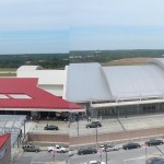
RDU Shows Off Terminal 2

On Saturday the Raleigh-Durham Airport Authority opened the doors to Phase One of the new Terminal 2 to the public with an impressive open house. The celebration showed off the new 920,000 square foot, $570 million terminal which will offer expanded security areas and improved efficiency with check-in and baggage security and routing.
After being shuttled to the upper levels of the hourly parking garage, visitors were greeted in the parking plaza with a jazz band, the first of many dotted throughout the terminal during this seminal event. Upon entering the front door of the terminal, it is easy to be swept away by the arcing, curved ceiling. Made of glue-laminated layers, the sturdy wood beams carry a shape reminiscent of a wing’s airfoil shape. Dramatic windows have been incorporated to allow in much natural light. The ticketing area contains two island style ticketing stations as well as individual kiosks for express check in.
The layout for the new terminal is essentially the same as that for the old Terminal C; a big “H”. The isthmus, again, is the site of security, only this time, there is no grade change until one is beyond the security areas.
The single, long concourse is similar to that in Terminal C, however the building is about 25 feet wider. The extra room accommodates bidrectional travelators as well as numerous full-service restaurants. The ceiling is a continuation of the arched airfoil concept, and contains many strips of glass to allow in natural light. The three big restaurants that will be open in this phase are 42nd Street Oyster Bar, Carolina Ale House, and Gordon Beirsch.
The concourse features some welcome improvements. The bathrooms are large and well-lit. The seating areas at the gates have some end tables with hidden power outlets. While AC outlets are offered, other form factors such as USB are offered. Finally, the large displays throughout the concourse are on par with the flatscreen displays that are appearing in the nation’s best airports.
As stated before, the isthmus is on the ticketing level, so arriving passengers must ride up a short escalator, then down a long escalator to access the baggage claim areas. The baggage claim area is unremarkable. The best kept secret in this complex, however, is the aluminum tree sculpture at the baggage claim entrance on the lower level. The tree’s base is outside, though some of its branches seemingly “pass through” the building’s two-story windows.
The terminal will no doubt offer an improved ticketing, security, and dining experience. The use of large windows will allow the building to utilize natural light for most of the time that passengers are using the building. Overall, the architectural design is stunning, and will make an excellent impression on those arriving to our area for the first time.

However, upon leaving the building, I have to wonder if this is the best way we could have spent just over half a billion dollars. Will the added natural light’s savings be offset by the additional costs to heat and condition the vast spaces inside the terminal? Will the movement of passengers up and down escalators eventually be seen as a backward way to move people? The facility only offers 4 more gates than Terminal C offered. Will this offer adequate revenues to help pay for this very expensive building? Will people actually use these full-service restaurants on the concourse? I can see this working in a hub setting, but in a point-to-point airport, the only customers they will get is those arriving early for their flight.
The new terminal is much like getting new shoes to wear with suits when your old shoes weren’t that bad…and your casual shoes are embarrassingly awful. The explanation I was given for replacing Terminal C first, instead of Terminal A, is that the airport could not move all of Terminal A’s functions into Terminal C while Terminal A is being replaced. With Terminal 2, they supposedly will be able to move the Terminal A airlines to 2 while replacing A. How will they accomplish this with just four more gates in Terminal 2?
Unfortunately Terminal 2 is another giant missed opportunity in RDU’s history. Ever since 1987 we have operated two airports at RDU; one right across the street from the other. Whether it be parking decks, ticketing areas, baggage claims, runways, control towers, or concourses, there are at least two of everything at RDU. If we’re building a baggage claim facility, a ticketing area, and a security area, why not build such that both concourses can use it?
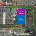
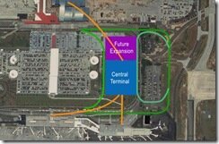
By building a central terminal and connecting it to just the concourses in the existing terminals, RDU could have set itself up for easy, efficient expansion and renovation in the future as well as incredible efficiency in the present. This design is called the landside/airside design and it has been so beloved in Tampa since 1971 that Orlando used it when it built its new airport in 1981. A central terminal almost the size of Orlando’s could easily fit on the NE side of RDU’s parking decks. People movers are so flexible, that future gates could be put virtually anywhere along the runways.
 There are two main arguments I’ve heard against the landside/airside design for RDU. One is that Southwest Airlines likes their arrangement in the Terminal B section of Terminal A. They have full control of their gates, their security area, and their baggage claim. They have apparently been resistant to any changes. Second, the inter-runway space between RDU’s two primary runways is much smaller than most airports. The original design was to build twin runways beside Terminal C, so the 5L/23R runway was placed as close as possible to Terminal C to allow for its eventual twin.
That said, most airside/landside arrangements have central terminals, but there is no law stating that the central terminal cannot be offset, as depicted above. (The green lines represent roadways and the orange lines represent people movers. Terminals 2 and C can be seen in the top of the picture, while Terminal A is at the bottom.). In fact, if the road entering the airport could be aligned to run along the edge of the parking decks, it would be entirely possible to rebuild Terminal A as a two-sided concourse.
While Terminal 2 is will be impressing a lot of people in the next few years, it depressing to think of what could have been.
NYC Joins Cash-Strapped Transit Cities
New York City’s transit agency has announced plans to wrap subway trains in advertising. In the face of increased ridership, the authority faces a projected deficit of $900 million next year, and is considering cutting subway, bus, and commuter service to ease budget woes.
Recent Stories
- North Carolina Loses The Great Teacher February 9, 2015
- City Lays Markings for Currituck Obstacle Course February 4, 2015
- History Making Heels and Wolfpack Prepare for Battle January 14, 2015
- 25 Predictions for 2015 January 5, 2015
- Raleigh’s 10 Biggest Stories of 2014 January 2, 2015
- 2014: The Rain Year January 2, 2015
- Tupelo Honey Sets New Casual Standard December 1, 2014
- 2013 Predictions. A Look Back November 18, 2014
- Wicked Taco Bringing Fresh-Mex to Western Blvd November 17, 2014
- DOT Unveils I-440 Widening Plans November 12, 2014
- County Power Shift Brings Major Changes to Raleigh’s Future November 5, 2014
- Jarrett Bay Store Coming to Crabtree September 25, 2014
- FirstWatch Coming to Glenwood Avenue September 9, 2014
- Big Shindig Releases Set Times September 5, 2014
- Appearance Commission to Review Residence Inn September 3, 2014


